Terni is an art history book to browse through to discover the nooks and crannies of the city and its priceless territory characteristic of the Umbria-Marches Apennines.
A tour of Terni’s historic center
The historic center and its historical and architectural stratifications can be discovered through thematic itineraries rediscovering Roman Terni, medieval Terni, Renaissance Terni, early 20th century architecture and more properly industrial Terni.
Roman Terni itinerary
There are few traces from the time of the Umbrians-the steel mills insist over the large area where necropolis of these peoples were found-some works and monuments from the Roman period when the city was called Interamna Nahars remain instead.
The itinerary ‘urban area of the town hall, monumentalized in the 1st century, are visible: the large opus quadratum walls on Giannelli Street that support the embankment on which the Public Gardens and the Faustus Amphitheater stand on Bishop’s Street; there are no major traces of the theater was in today’s Aminale Street nor of the Forum that insisted on today’s Republic Square.
Both artifacts from the Umbrian and Roman periods are preserved in the Archaeological Museum exceptional place to admire works from the city’s earliest history.
Medieval Terni itinerary
In the urban fabric of the city several medieval monuments are worth visiting through an itinerary around what were the six districts in the Middle Ages: Fabri, Castello, Rigonfi, Adultrini, Di Sotto, Amingoni.
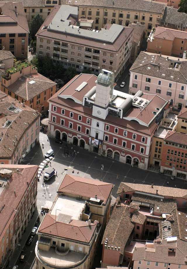
From the city was accessed through six gates, among the two still visible we will start from Porta Sant’Angelo from which one can reach the ancient Church of Sant’Alò. The crypt of the Cathedral of Terni (link to POI) has medieval origins, and from Piazza Duomo one can easily reach Via Roma on which stands the Barbarasa Tower. A short distance from Palazzo Spada (link) is the Church of San Salvatore one of the oldest and most evocative religious buildings in Terni from which one can reach Piazza della Repubblica and the Former Town Hall. In the nearby square of the same name rises the Church of San Pietro, then along Corso Vecchio the Church of San Lorenzo and the Castelli Tower. Nearby on Angeloni Street is the Church of San Cristoforo a little further away the Porta Spoletina structure. Before returning, a visit to one of the best-preserved medieval buildings, Palazzo Mazzancolli, is worthwhile.
Terni Renaissance Itinerary
The Renaissance asserted itself in Terni through numerous monuments that, to this day for the most part, still enrich the city’s urban layout and are to be enjoyed on a splendid walk with your nose to the sky.
A tour of Renaissance Terni can only start, in Piazza Ridolfi, from Palazzo Spada designed by Antonio da Sangallo the Younger and now the seat of the Municipality and the nearby Palazzo Pierfelici with its early 16th-century portal. Two of the city’s most important buildings are, in Piazza Duomo, the Palazzo Bianchini-Riccardi and the Cathedral of Santa Maria Assunta the mother-church of the Diocese of Terni-Narni-Amelia. In Via del Teatro Romano rises the beauty of Palazzo Gazzoli and in nearby Via delle Tre Colonne Palazzo Sciamanna. Around Via Cavour one can admire: Palazzo Alberici with its splendid 15th-century courtyard, Palazzo Possenti, Palazzo Fabrizi and Palazzo Mastrozzi-Magroni. In Via del Tribunale Palazzo Pressio-Colonnese, then in the street of the same name the beautiful Palazzo Carrara and finally, returning to Piazza Ridolfi: in the street of the same name Palazzo Manassei and in Via Garibaldi Palazzo Montani.
Renaissance painting production is also notable, starting with Bartolomeo di Tommaso da Foligno’s frescoes depicting the Last Judgment in the Paradisi Chapel in the Church of San Francesco.
The Museum of Modern and Contemporary Art also preserves a panel with the Marriage of St. Catherine by Benozzo Gozzoli from 1466; a banner with the Crucifixion by Niccolò Alunno from 1496; and works by Spagna, Piermatteo d’Amelia and Domenico Alfani. Between the 16th and 17th centuries impressive work is done in the Basilica of St. Valentine, which is being rebuilt.
Terni itinerary of the early twentieth century
Fundamental to the city was the work of some of the architects of the early twentieth century: the works of Cesare Bazzani and Mario Ridolfi embellish and make precious some of the city’s iconic places, starting with the central square where Ridolfi’s Piazza Tacito Fountain towers and, to the side, Bazzani’s Palazzo del Governo. On Corso Tacito is Bazzani’s Palazzina Alterrocca and Ridolfi’s Casa Chitarrini, in Largo Villa Glori. Palazzo Briganti in St. Peter’s Square and the former Post Office Building in St. John Decollate Square are also the work of one by Ridolfi, the other by Bazzani.
Terni industrial route
The City of Steel could not but also have a route dedicated to that industry that has characterized Terni since the 19th century.
Highlighting this industrial vocation are many works around the city: from Arnaldo Pomodoro’s Lance of Light obelisk at the end of Corso del Popolo, to Agapito Miniucchi’s Hyperion in the Steel Square and the Great Press, a 12,000-ton monument placed in the square in front of the train station.
Important sites of industrial archaeology today transformed into museums or film and multimedia hubs, such as the Museum of Weapons located right in the former Factory Valleys, heights, lakes and rivers dotted with castles, villages, abbeys, places of historical interest, d’Armi, or the “CAOS – Centro Arti Opificio Siri” (link to POI), a cultural center dedicated to the enjoyment of the arts, as well as home to the Archaeological Museum and the Museum of Contemporary Art, created from the conversion of the former SIRI chemical factory.
The territory and the many beautiful hamlets
From the Valnerina to the Val Serra, from the rushing flow of the Nera River to the slow flow along the Via Flaminia, from settlements located on the plains to times that rise to the highest points of the mountains: the territory of the city is made up of many places of interest, each with its own peculiarities, each with its own traditions, but also each united in a single proud land, that of the territory of the Municipality of Terni.
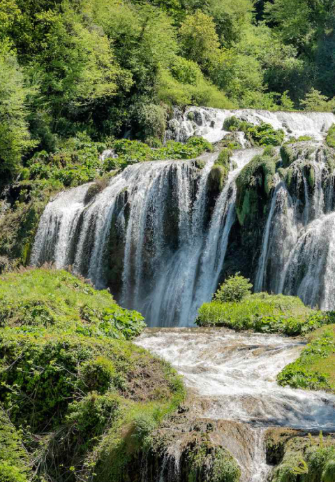
The Valnerina ternana and the Marmore Falls
Along the beautiful stretch of the lower-middle reaches of the Nera River, the Valnerina Ternana – which includes, in addition to Terni, the municipalities of Arrone, Montefranco, Polino and Ferentillo and which together form the Nera River Park – mountains, rivers and forests embellished by a myriad of small villages, medieval castles, watchtowers, abbeys, hermitages and beautiful towns, such as Papigno and San Liberatore, Collestatte and Torre Orsina that guard the prince attractor of our lands: the Marmore Falls.
The possibility of practicing all kinds of outdoor sports, that of discovering areas of historical and cultural interest, make this area one of the most interesting in Terni and our district.
Miranda castle on the border of the Rieti region and Piediluco Lake
A little further south of the Valnerina, bordering the territory of Rieti, Larviano first and Miranda -famous for its splendid Christmas star-is one of the most evocative castles in the area with its views that span the entire basin and the presence of routes and itineraries among the greenery that reach as far as Lake Piediluco pearl of the Terni area with its splendid village and the sports activities that have made it internationally famous for rowing.
The Valserra
Another extremely suggestive valley is the one that opens up around the Serra stream: with the territory that starts to the northeast of the Terni basin and that, alternating with the valley of the Tessino traversed by the Via Flaminia, forms a natural link between Terni and Spoleto.
Here, too, castles and watchtowers, dot the slopes of the reliefs rising in relation to mid-coast road routes: from the basin: Rocca San Zenone, Acquapalombo, Battiferro, Cecalocco, Appecano, Poggio Lavarino, Giuncano, Polenaco, Pracchia and Porzano, are the names of the settlements that go to make up this splendid district once subject to the Terre Arnolfe.
Cesi, the Terre Arnolfe and Torre Maggiore
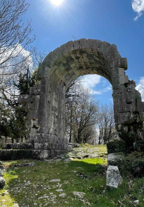
On the slopes of the mountain of Torre Maggiore, which at the top of 1121 meters guards an evocative pre-Roman Sanctuary, the beautiful and scenic village of Cesi is what remains of the city that was the capital of the Terre Arnolfe whose domains spanned a vast territory. Below Cesi the ancient Roman municipality of Carsulae, bordering the territory of the municipality of San Gemini today is an archaeological area of extreme charm.
Along the southern side of the Via Flaminia
Along the Via Flaminia, south of Terni stands the proud and beautiful castle of Collescipoli, an ancient municipality and the first stronghold defending the border with Narni in the Middle Ages.